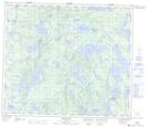
Maps showing Dunn Island, 71-20W, Manitoba
Dunn Island is a Island located in 71-20W, Manitoba.
- Latitude: 55° 7' 20'' North (decimal: 55.1222000)
- Longitude: 100° 31' 43'' West (decimal: -100.5286000)
- Topography Feature Category: Island
- Geographical Feature: Island
- Canadian Province/Territory: Manitoba
- Location: 71-20W
- Atlas of Canada Locator Map: Dunn Island
- GPS Coordinate Locator Map: Dunn Island Lat/Long
Dunn Island NTS Map Sheets