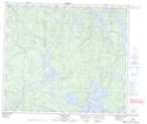
Maps showing Chaboyer Island, 73-21W, Manitoba
Chaboyer Island is a Island located in 73-21W, Manitoba.
- Latitude: 55° 17' 34'' North (decimal: 55.2927999)
- Longitude: 100° 37' 41'' West (decimal: -100.6280999)
- Topography Feature Category: Island
- Geographical Feature: Island
- Canadian Province/Territory: Manitoba
- Location: 73-21W
- Atlas of Canada Locator Map: Chaboyer Island
- GPS Coordinate Locator Map: Chaboyer Island Lat/Long
Chaboyer Island NTS Map Sheets