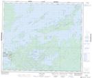
Maps showing Bray Island, 66-21E1, Manitoba
Bray Island is a Island located in 66-21E1, Manitoba.
- Latitude: 54° 40' 54'' North (decimal: 54.6817000)
- Longitude: 94° 17' 29'' West (decimal: -94.2914000)
- Topography Feature Category: Island
- Geographical Feature: Island
- Canadian Province/Territory: Manitoba
- Location: 66-21E1
- Atlas of Canada Locator Map: Bray Island
- GPS Coordinate Locator Map: Bray Island Lat/Long
Bray Island NTS Map Sheets