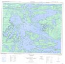
Maps showing Arthur Moore Island, 58-18E, Manitoba
Arthur Moore Island is a Island located in 58-18E, Manitoba.
- Latitude: 53° 59' 12'' North (decimal: 53.9866999)
- Longitude: 94° 50' 20'' West (decimal: -94.8389000)
- Topography Feature Category: Island
- Geographical Feature: Island
- Canadian Province/Territory: Manitoba
- Location: 58-18E
- Atlas of Canada Locator Map: Arthur Moore Island
- GPS Coordinate Locator Map: Arthur Moore Island Lat/Long
Arthur Moore Island NTS Map Sheets