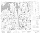
Maps showing Bruneau Island, 121-3W, Manitoba
Bruneau Island is a Island located in 121-3W, Manitoba.
- Latitude: 59° 29' 12'' North (decimal: 59.4867000)
- Longitude: 97° 51' 30'' West (decimal: -97.8583000)
- Topography Feature Category: Island
- Geographical Feature: Island
- Canadian Province/Territory: Manitoba
- Location: 121-3W
- Atlas of Canada Locator Map: Bruneau Island
- GPS Coordinate Locator Map: Bruneau Island Lat/Long
Bruneau Island NTS Map Sheets