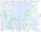
Maps showing Gunnlaugsson Island, 34 - 24 - 10W, Manitoba
Gunnlaugsson Island is a Island located in 34 - 24 - 10W, Manitoba.
- Latitude: 51° 6' 57'' North (decimal: 51.1158333)
- Longitude: 98° 45' 56'' West (decimal: -98.7655555)
- Topography Feature Category: Island
- Geographical Feature: Island
- Canadian Province/Territory: Manitoba
- Location: 34 - 24 - 10W
- Atlas of Canada Locator Map: Gunnlaugsson Island
- GPS Coordinate Locator Map: Gunnlaugsson Island Lat/Long
Gunnlaugsson Island NTS Map Sheets