Maps showing Prince Michael of Kent Lake, 73 - 27W, Manitoba
Prince Michael of Kent Lake is a Lake located in 73 - 27W, Manitoba.
- Latitude: 55° 21' 33'' North (decimal: 55.3591666)
- Longitude: 101° 31' 35'' West (decimal: -101.5263889)
- Topography Feature Category: Lake
- Geographical Feature: Lake
- Canadian Province/Territory: Manitoba
- Location: 73 - 27W
- Atlas of Canada Locator Map: Prince Michael of Kent Lake
- GPS Coordinate Locator Map: Prince Michael of Kent Lake Lat/Long
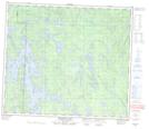
Prince Michael of Kent Lake NTS Map Sheets