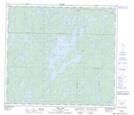
Maps showing Spearin Island, 9-88-19-W, Manitoba
Spearin Island is a Island located in 9-88-19-W, Manitoba.
- Latitude: 56° 36' 48'' North (decimal: 56.6133000)
- Longitude: 100° 25' 51'' West (decimal: -100.4307999)
- Topography Feature Category: Island
- Geographical Feature: Island
- Canadian Province/Territory: Manitoba
- Location: 9-88-19-W
- Atlas of Canada Locator Map: Spearin Island
- GPS Coordinate Locator Map: Spearin Island Lat/Long
Spearin Island NTS Map Sheets