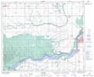
Maps showing Cherry Ridge, 8-51-15-W2, Saskatchewan
Cherry Ridge is a Unincorporated area located in 8-51-15-W2, Saskatchewan and has an elevation of 396 meters.
- Latitude: 53° 24' North (decimal: 53.4000424)
- Longitude: 104° 10' West (decimal: -104.1671297)
- Topography Feature Category: Unincorporated area
- Geographical Feature: Locality
- Canadian Province/Territory: Saskatchewan
- Elevation: 396 meters
- Location: 8-51-15-W2
- Atlas of Canada Locator Map: Cherry Ridge
- GPS Coordinate Locator Map: Cherry Ridge Lat/Long
Cherry Ridge NTS Map Sheets