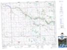
Maps showing Inchkeith, 15-13-4-W2, Saskatchewan
Inchkeith is a Unincorporated area located in 15-13-4-W2, Saskatchewan and has an elevation of 659 meters.
- Latitude: 50° 5' North (decimal: 50.0833487)
- Longitude: 102° 28' West (decimal: -102.4671638)
- Topography Feature Category: Unincorporated area
- Geographical Feature: Hamlet
- Canadian Province/Territory: Saskatchewan
- Elevation: 659 meters
- Location: 15-13-4-W2
- Atlas of Canada Locator Map: Inchkeith
- GPS Coordinate Locator Map: Inchkeith Lat/Long