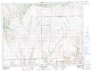
Maps showing Caton Creek, 9-7-24-W3, Saskatchewan
Caton Creek is a River located in 9-7-24-W3, Saskatchewan and has an elevation of 1164 meters.
- Latitude: 49° 33' North (decimal: 49.5500242)
- Longitude: 109° 12' West (decimal: -109.2007338)
- Topography Feature Category: River
- Geographical Feature: Creek
- Canadian Province/Territory: Saskatchewan
- Elevation: 1164 meters
- Location: 9-7-24-W3
- Atlas of Canada Locator Map: Caton Creek
- GPS Coordinate Locator Map: Caton Creek Lat/Long
Caton Creek NTS Map Sheets