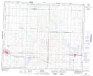
Maps showing Cazalet, 28-35-13-W3, Saskatchewan
Cazalet is a Unincorporated area located in 28-35-13-W3, Saskatchewan.
- Latitude: 52° 2' North (decimal: 52.0333848)
- Longitude: 107° 48' West (decimal: -107.8006637)
- Topography Feature Category: Unincorporated area
- Geographical Feature: Railway Point
- Canadian Province/Territory: Saskatchewan
- Location: 28-35-13-W3
- Atlas of Canada Locator Map: Cazalet
- GPS Coordinate Locator Map: Cazalet Lat/Long