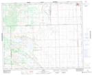
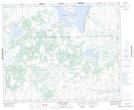
Maps showing Cherry Lake, 35-41-25-W3, Saskatchewan
Cherry Lake is a Lake located in 35-41-25-W3, Saskatchewan and has an elevation of 617 meters.
- Latitude: 52° 35' North (decimal: 52.5834067)
- Longitude: 109° 30' West (decimal: -109.5007464)
- Topography Feature Category: Lake
- Geographical Feature: Lake
- Canadian Province/Territory: Saskatchewan
- Elevation: 617 meters
- Location: 35-41-25-W3
- Atlas of Canada Locator Map: Cherry Lake
- GPS Coordinate Locator Map: Cherry Lake Lat/Long
Cherry Lake NTS Map Sheets