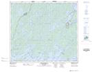
Maps showing Fuller Island, Saskatchewan
Fuller Island is a Island located in Saskatchewan and has an elevation of 356 meters.
- Latitude: 55° 16' North (decimal: 55.2667367)
- Longitude: 104° 50' West (decimal: -104.8337777)
- Topography Feature Category: Island
- Geographical Feature: Island
- Canadian Province/Territory: Saskatchewan
- Elevation: 356 meters
- Atlas of Canada Locator Map: Fuller Island
- GPS Coordinate Locator Map: Fuller Island Lat/Long
Fuller Island NTS Map Sheets