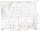
Maps showing Clarence Coulee, 8-24,25-W3, Saskatchewan
Clarence Coulee is a Valley located in 8-24,25-W3, Saskatchewan and has an elevation of 1163 meters.
- Latitude: 49° 38' North (decimal: 49.6333605)
- Longitude: 109° 14' West (decimal: -109.2340701)
- Topography Feature Category: Valley
- Geographical Feature: Coulee
- Canadian Province/Territory: Saskatchewan
- Elevation: 1163 meters
- Location: 8-24,25-W3
- Atlas of Canada Locator Map: Clarence Coulee
- GPS Coordinate Locator Map: Clarence Coulee Lat/Long
Clarence Coulee NTS Map Sheets