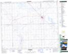
Maps showing Kerrobert, Saskatchewan
Kerrobert is a Town located in Saskatchewan and has an elevation of 683 meters.
- Latitude: 51° 55' 18'' North (decimal: 51.9216639)
- Longitude: 109° 8' 26'' West (decimal: -109.1406777)
- Topography Feature Category: Town
- Geographical Feature: Town
- Canadian Province/Territory: Saskatchewan
- Elevation: 683 meters
- Atlas of Canada Locator Map: Kerrobert
- GPS Coordinate Locator Map: Kerrobert Lat/Long
Kerrobert NTS Map Sheets