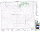
Maps showing Glenellen, 12-33-17-W3, Saskatchewan
Glenellen is a Unincorporated area located in 12-33-17-W3, Saskatchewan and has an elevation of 700 meters.
- Latitude: 51° 49' North (decimal: 51.8167178)
- Longitude: 108° 16' West (decimal: -108.2673622)
- Topography Feature Category: Unincorporated area
- Geographical Feature: Locality
- Canadian Province/Territory: Saskatchewan
- Elevation: 700 meters
- Location: 12-33-17-W3
- Atlas of Canada Locator Map: Glenellen
- GPS Coordinate Locator Map: Glenellen Lat/Long
Glenellen NTS Map Sheets