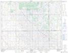
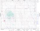
Maps showing Gregherd, 32-24-18-W2, Saskatchewan
Gregherd is a Unincorporated area located in 32-24-18-W2, Saskatchewan and has an elevation of 573 meters.
- Latitude: 51° 5' North (decimal: 51.0833737)
- Longitude: 104° 30' West (decimal: -104.5005553)
- Topography Feature Category: Unincorporated area
- Geographical Feature: Locality
- Canadian Province/Territory: Saskatchewan
- Elevation: 573 meters
- Location: 32-24-18-W2
- Atlas of Canada Locator Map: Gregherd
- GPS Coordinate Locator Map: Gregherd Lat/Long
Gregherd NTS Map Sheets