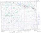
Maps showing Hazel Dell, 35-35-7-W2, Saskatchewan
Hazel Dell is a Hamlet located in 35-35-7-W2, Saskatchewan and has an elevation of 593 meters.
- Latitude: 51° 58' 39'' North (decimal: 51.9775722)
- Longitude: 102° 58' 34'' West (decimal: -102.9761082)
- Topography Feature Category: Hamlet
- Geographical Feature: Organized Hamlet
- Canadian Province/Territory: Saskatchewan
- Elevation: 593 meters
- Location: 35-35-7-W2
- Atlas of Canada Locator Map: Hazel Dell
- GPS Coordinate Locator Map: Hazel Dell Lat/Long
Hazel Dell NTS Map Sheets