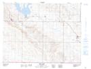
Maps showing Lacordaire, 18-1-29-W2, Saskatchewan
Lacordaire is a Unincorporated area located in 18-1-29-W2, Saskatchewan and has an elevation of 800 meters.
- Latitude: 49° 2' North (decimal: 49.0333614)
- Longitude: 105° 52' West (decimal: -105.8672373)
- Topography Feature Category: Unincorporated area
- Geographical Feature: Locality
- Canadian Province/Territory: Saskatchewan
- Elevation: 800 meters
- Location: 18-1-29-W2
- Atlas of Canada Locator Map: Lacordaire
- GPS Coordinate Locator Map: Lacordaire Lat/Long
Lacordaire NTS Map Sheets