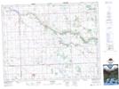
Maps showing Langbank, 12,13-3-W2, Saskatchewan
Langbank is a Hamlet located in 12,13-3-W2, Saskatchewan and has an elevation of 664 meters.
- Latitude: 50° 2' 54'' North (decimal: 50.0483110)
- Longitude: 102° 17' 49'' West (decimal: -102.2969999)
- Topography Feature Category: Hamlet
- Geographical Feature: Organized Hamlet
- Canadian Province/Territory: Saskatchewan
- Elevation: 664 meters
- Location: 12,13-3-W2
- Atlas of Canada Locator Map: Langbank
- GPS Coordinate Locator Map: Langbank Lat/Long