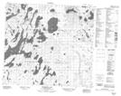
Maps showing Devils Lake, Saskatchewan
Devils Lake is a Lake located in Saskatchewan and has an elevation of 472 meters.
- Latitude: 56° 43' North (decimal: 56.7167623)
- Longitude: 107° 53' West (decimal: -107.8840139)
- Topography Feature Category: Lake
- Geographical Feature: Lake
- Canadian Province/Territory: Saskatchewan
- Elevation: 472 meters
- Atlas of Canada Locator Map: Devils Lake
- GPS Coordinate Locator Map: Devils Lake Lat/Long
Devils Lake NTS Map Sheets