Maps showing Dubuc, 3-20-4-W2, Saskatchewan
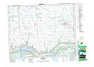
Dubuc is a Village located in 3-20-4-W2, Saskatchewan and has an elevation of 539 meters.
- Latitude: 50° 41' 00'' North (decimal: 50.6832193)
- Longitude: 102° 28' 37'' West (decimal: -102.4768694)
- Topography Feature Category: Village
- Geographical Feature: Village
- Canadian Province/Territory: Saskatchewan
- Elevation: 539 meters
- Location: 3-20-4-W2
- Atlas of Canada Locator Map: Dubuc
- GPS Coordinate Locator Map: Dubuc Lat/Long