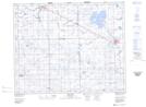
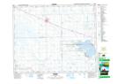
Maps showing Duck Hunting Creek, 28-33-14-W2, Saskatchewan
Duck Hunting Creek is a River located in 28-33-14-W2, Saskatchewan and has an elevation of 538 meters.
- Latitude: 51° 51' North (decimal: 51.8500065)
- Longitude: 103° 55' West (decimal: -103.9171851)
- Topography Feature Category: River
- Geographical Feature: Creek
- Canadian Province/Territory: Saskatchewan
- Elevation: 538 meters
- Location: 28-33-14-W2
- Atlas of Canada Locator Map: Duck Hunting Creek
- GPS Coordinate Locator Map: Duck Hunting Creek Lat/Long
Duck Hunting Creek NTS Map Sheets