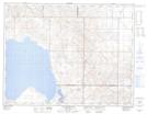
Maps showing Dunkirk, 36-12-28-W2, Saskatchewan
Dunkirk is a Unincorporated area located in 36-12-28-W2, Saskatchewan and has an elevation of 687 meters.
- Latitude: 50° 2' North (decimal: 50.0333626)
- Longitude: 105° 43' West (decimal: -105.7172405)
- Topography Feature Category: Unincorporated area
- Geographical Feature: Hamlet
- Canadian Province/Territory: Saskatchewan
- Elevation: 687 meters
- Location: 36-12-28-W2
- Atlas of Canada Locator Map: Dunkirk
- GPS Coordinate Locator Map: Dunkirk Lat/Long
Dunkirk NTS Map Sheets