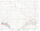
Maps showing Lumsden Beach, 7-21-21-W2, Saskatchewan
Lumsden Beach is a Village located in 7-21-21-W2, Saskatchewan and has an elevation of 521 meters.
- Latitude: 50° 45' 50'' North (decimal: 50.7639304)
- Longitude: 104° 53' 57'' West (decimal: -104.8992971)
- Topography Feature Category: Village
- Geographical Feature: Resort Village
- Canadian Province/Territory: Saskatchewan
- Elevation: 521 meters
- Location: 7-21-21-W2
- Atlas of Canada Locator Map: Lumsden Beach
- GPS Coordinate Locator Map: Lumsden Beach Lat/Long