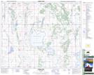
Maps showing St. Benedict, 33-41-24-W2, Saskatchewan
St. Benedict is a Village located in 33-41-24-W2, Saskatchewan and has an elevation of 572 meters.
- Latitude: 52° 34' 0'' North (decimal: 52.5667532)
- Longitude: 105° 23' 36'' West (decimal: -105.3932138)
- Topography Feature Category: Village
- Geographical Feature: Village
- Canadian Province/Territory: Saskatchewan
- Elevation: 572 meters
- Location: 33-41-24-W2
- Atlas of Canada Locator Map: St. Benedict
- GPS Coordinate Locator Map: St. Benedict Lat/Long