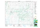
Maps showing St. Brieux, 24-42-21-W2, Saskatchewan
St. Brieux is a Town located in 24-42-21-W2, Saskatchewan and has an elevation of 542 meters.
- Latitude: 52° 38' 14'' North (decimal: 52.6371778)
- Longitude: 104° 53' 6'' West (decimal: -104.8849406)
- Topography Feature Category: Town
- Geographical Feature: Town
- Canadian Province/Territory: Saskatchewan
- Elevation: 542 meters
- Location: 24-42-21-W2
- Atlas of Canada Locator Map: St. Brieux
- GPS Coordinate Locator Map: St. Brieux Lat/Long