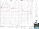
Maps showing St. Gregor, 17-37-20-W2, Saskatchewan
St. Gregor is a Village located in 17-37-20-W2, Saskatchewan and has an elevation of 578 meters.
- Latitude: 52° 10' 36'' North (decimal: 52.1766806)
- Longitude: 104° 49' 35'' West (decimal: -104.8265028)
- Topography Feature Category: Village
- Geographical Feature: Village
- Canadian Province/Territory: Saskatchewan
- Elevation: 578 meters
- Location: 17-37-20-W2
- Atlas of Canada Locator Map: St. Gregor
- GPS Coordinate Locator Map: St. Gregor Lat/Long