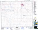
Maps showing Sandgren, 16-27-23-W3, Saskatchewan
Sandgren is a Unincorporated area located in 16-27-23-W3, Saskatchewan.
- Latitude: 51° 19' North (decimal: 51.3167211)
- Longitude: 109° 10' West (decimal: -109.1674068)
- Topography Feature Category: Unincorporated area
- Geographical Feature: Railway Point
- Canadian Province/Territory: Saskatchewan
- Location: 16-27-23-W3
- Atlas of Canada Locator Map: Sandgren
- GPS Coordinate Locator Map: Sandgren Lat/Long
Sandgren NTS Map Sheets