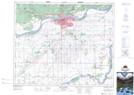
Maps showing Prince Albert Sanatorium, 9-49-26-W2, Saskatchewan
Prince Albert Sanatorium is a Unincorporated area located in 9-49-26-W2, Saskatchewan.
- Latitude: 53° 13' North (decimal: 53.2167067)
- Longitude: 105° 44' West (decimal: -105.7338394)
- Topography Feature Category: Unincorporated area
- Geographical Feature: Locality
- Canadian Province/Territory: Saskatchewan
- Location: 9-49-26-W2
- GPS Coordinate Locator Map: Prince Albert Sanatorium Lat/Long
Prince Albert Sanatorium NTS Map Sheets