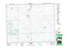
Maps showing Sintaluta, 33-17-11-W2, Saskatchewan
Sintaluta is a Town located in 33-17-11-W2, Saskatchewan and has an elevation of 602 meters.
- Latitude: 50° 28' 37'' North (decimal: 50.4768999)
- Longitude: 103° 26' 59'' West (decimal: -103.4496750)
- Topography Feature Category: Town
- Geographical Feature: Town
- Canadian Province/Territory: Saskatchewan
- Elevation: 602 meters
- Location: 33-17-11-W2
- Atlas of Canada Locator Map: Sintaluta
- GPS Coordinate Locator Map: Sintaluta Lat/Long