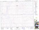
Maps showing Smiley, 3-31-25-W3, Saskatchewan
Smiley is a Village located in 3-31-25-W3, Saskatchewan and has an elevation of 693 meters.
- Latitude: 51° 37' 44'' North (decimal: 51.6287556)
- Longitude: 109° 28' 17'' West (decimal: -109.4714417)
- Topography Feature Category: Village
- Geographical Feature: Village
- Canadian Province/Territory: Saskatchewan
- Elevation: 693 meters
- Location: 3-31-25-W3
- Atlas of Canada Locator Map: Smiley
- GPS Coordinate Locator Map: Smiley Lat/Long
Smiley NTS Map Sheets