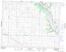
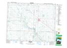
Maps showing Bosshill Creek, 13-12-30-W, Saskatchewan
Bosshill Creek is a River located in 13-12-30-W, Saskatchewan and has an elevation of 559 meters.
- Latitude: 50° 0' 40'' North (decimal: 50.0111113)
- Longitude: 101° 26' 52'' West (decimal: -101.4476997)
- Topography Feature Category: River
- Geographical Feature: Creek
- Canadian Province/Territory: Saskatchewan
- Elevation: 559 meters
- Location: 13-12-30-W
- Atlas of Canada Locator Map: Bosshill Creek
- GPS Coordinate Locator Map: Bosshill Creek Lat/Long
Bosshill Creek NTS Map Sheets