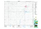
Maps showing Burr, 31-35-22-W2, Saskatchewan
Burr is a Unincorporated area located in 31-35-22-W2, Saskatchewan and has an elevation of 556 meters.
- Latitude: 52° 3' North (decimal: 52.0500281)
- Longitude: 105° 8' West (decimal: -105.1338942)
- Topography Feature Category: Unincorporated area
- Geographical Feature: Hamlet
- Canadian Province/Territory: Saskatchewan
- Elevation: 556 meters
- Location: 31-35-22-W2
- Atlas of Canada Locator Map: Burr
- GPS Coordinate Locator Map: Burr Lat/Long