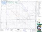
Maps showing Qu'Appelle Valley Dam, 23-4-3, Saskatchewan
Qu'Appelle Valley Dam is a Hydraulic construction located in 23-4-3, Saskatchewan and has an elevation of 552 meters.
- Latitude: 50° 59' North (decimal: 50.9833643)
- Longitude: 106° 26' West (decimal: -106.4339528)
- Topography Feature Category: Hydraulic construction
- Geographical Feature: Dam
- Canadian Province/Territory: Saskatchewan
- Elevation: 552 meters
- Location: 23-4-3
- Atlas of Canada Locator Map: Qu'Appelle Valley Dam
- GPS Coordinate Locator Map: Qu'Appelle Valley Dam Lat/Long
Qu'Appelle Valley Dam NTS Map Sheets