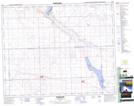
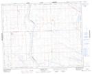
Maps showing Tramping Lake, 33-36-21-W3, Saskatchewan
Tramping Lake is a Village located in 33-36-21-W3, Saskatchewan and has an elevation of 670 meters.
- Latitude: 52° 8' 10'' North (decimal: 52.1361249)
- Longitude: 108° 56' 57'' West (decimal: -108.9492167)
- Topography Feature Category: Village
- Geographical Feature: Village
- Canadian Province/Territory: Saskatchewan
- Elevation: 670 meters
- Location: 33-36-21-W3
- Atlas of Canada Locator Map: Tramping Lake
- GPS Coordinate Locator Map: Tramping Lake Lat/Long
Tramping Lake NTS Map Sheets