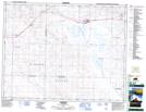
Maps showing Valjean, 25-17-5-W3, Saskatchewan
Valjean is a Unincorporated area located in 25-17-5-W3, Saskatchewan and has an elevation of 677 meters.
- Latitude: 50° 28' North (decimal: 50.4666993)
- Longitude: 106° 33' West (decimal: -106.5506162)
- Topography Feature Category: Unincorporated area
- Geographical Feature: Locality
- Canadian Province/Territory: Saskatchewan
- Elevation: 677 meters
- Location: 25-17-5-W3
- Atlas of Canada Locator Map: Valjean
- GPS Coordinate Locator Map: Valjean Lat/Long
Valjean NTS Map Sheets