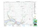
Maps showing Lebret, 2-21-13-W2, Saskatchewan
Lebret is a Village located in 2-21-13-W2, Saskatchewan and has an elevation of 490 meters.
- Latitude: 50° 45' 16'' North (decimal: 50.7544277)
- Longitude: 103° 41' 54'' West (decimal: -103.6982610)
- Topography Feature Category: Village
- Geographical Feature: Village
- Canadian Province/Territory: Saskatchewan
- Elevation: 490 meters
- Location: 2-21-13-W2
- Atlas of Canada Locator Map: Lebret
- GPS Coordinate Locator Map: Lebret Lat/Long
Lebret NTS Map Sheets