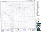
Maps showing D'Arcy, 12-29-19-W3, Saskatchewan
D'Arcy is a Unincorporated area located in 12-29-19-W3, Saskatchewan and has an elevation of 697 meters.
- Latitude: 51° 28' North (decimal: 51.4667183)
- Longitude: 108° 32' West (decimal: -108.5340440)
- Topography Feature Category: Unincorporated area
- Geographical Feature: Hamlet
- Canadian Province/Territory: Saskatchewan
- Elevation: 697 meters
- Location: 12-29-19-W3
- Atlas of Canada Locator Map: D'Arcy
- GPS Coordinate Locator Map: D'Arcy Lat/Long