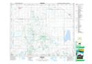
Maps showing Tiger Hills, 31-45-24-W2, Saskatchewan
Tiger Hills is a Unincorporated area located in 31-45-24-W2, Saskatchewan and has an elevation of 493 meters.
- Latitude: 52° 55' North (decimal: 52.9166980)
- Longitude: 105° 29' West (decimal: -105.4838534)
- Topography Feature Category: Unincorporated area
- Geographical Feature: Railway Point
- Canadian Province/Territory: Saskatchewan
- Elevation: 493 meters
- Location: 31-45-24-W2
- Atlas of Canada Locator Map: Tiger Hills
- GPS Coordinate Locator Map: Tiger Hills Lat/Long