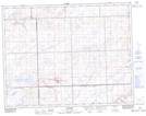
Maps showing Tompkins, 10-13-21-W3, Saskatchewan
Tompkins is a Village located in 10-13-21-W3, Saskatchewan and has an elevation of 810 meters.
- Latitude: 50° 3' 45'' North (decimal: 50.0624556)
- Longitude: 108° 47' 32'' West (decimal: -108.7921749)
- Topography Feature Category: Village
- Geographical Feature: Village
- Canadian Province/Territory: Saskatchewan
- Elevation: 810 meters
- Location: 10-13-21-W3
- Atlas of Canada Locator Map: Tompkins
- GPS Coordinate Locator Map: Tompkins Lat/Long