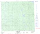
Maps showing Manny Creek, 76-25-W3, Saskatchewan
Manny Creek is a River located in 76-25-W3, Saskatchewan and has an elevation of 581 meters.
- Latitude: 55° 36' North (decimal: 55.6001028)
- Longitude: 109° 57' West (decimal: -109.9508473)
- Topography Feature Category: River
- Geographical Feature: Creek
- Canadian Province/Territory: Saskatchewan
- Elevation: 581 meters
- Location: 76-25-W3
- Atlas of Canada Locator Map: Manny Creek
- GPS Coordinate Locator Map: Manny Creek Lat/Long
Manny Creek NTS Map Sheets