Maps showing Air Ronge, Saskatchewan
Air Ronge is a Village located in Saskatchewan.
- Latitude: 55° 5' 23'' North (decimal: 55.0897360)
- Longitude: 105° 20' 29'' West (decimal: -105.3414667)
- Topography Feature Category: Village
- Geographical Feature: Northern Village
- Canadian Province/Territory: Saskatchewan
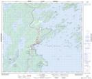
- Atlas of Canada Locator Map: Air Ronge
- GPS Coordinate Locator Map: Air Ronge Lat/Long
Air Ronge NTS Map Sheets