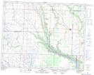
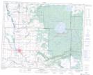
Maps showing Little Boggy Creek, 8-29-31-W, Saskatchewan
Little Boggy Creek is a River located in 8-29-31-W, Saskatchewan and has an elevation of 583 meters.
- Latitude: 51° 30' North (decimal: 51.4999905)
- Longitude: 101° 50' West (decimal: -101.8337969)
- Topography Feature Category: River
- Geographical Feature: Creek
- Canadian Province/Territory: Saskatchewan
- Elevation: 583 meters
- Location: 8-29-31-W
- Atlas of Canada Locator Map: Little Boggy Creek
- GPS Coordinate Locator Map: Little Boggy Creek Lat/Long
Little Boggy Creek NTS Map Sheets