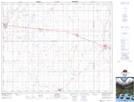
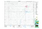
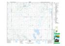
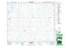
Maps showing St. Peter No. 369, Saskatchewan
St. Peter No. 369 is a Other municipal/district area - miscellaneous located in Saskatchewan.
- Latitude: 52° 15' 56'' North (decimal: 52.2656600)
- Longitude: 104° 49' 53'' West (decimal: -104.8313253)
- Topography Feature Category: Other municipal/district area - miscellaneous
- Geographical Feature: Rural Municipality
- Canadian Province/Territory: Saskatchewan
- Atlas of Canada Locator Map: St. Peter No. 369
- GPS Coordinate Locator Map: St. Peter No. 369 Lat/Long
St. Peter No. 369 NTS Map Sheets