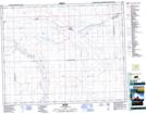
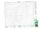
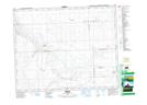
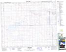
Maps showing Pleasant Valley No. 288, Saskatchewan
Pleasant Valley No. 288 is a Other municipal/district area - miscellaneous located in Saskatchewan.
- Latitude: 51° 29' 20'' North (decimal: 51.4889245)
- Longitude: 108° 19' 28'' West (decimal: -108.3243993)
- Topography Feature Category: Other municipal/district area - miscellaneous
- Geographical Feature: Rural Municipality
- Canadian Province/Territory: Saskatchewan
- Atlas of Canada Locator Map: Pleasant Valley No. 288
- GPS Coordinate Locator Map: Pleasant Valley No. 288 Lat/Long
Pleasant Valley No. 288 NTS Map Sheets