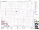
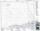
Maps showing Clinworth No. 230, Saskatchewan
Clinworth No. 230 is a Other municipal/district area - miscellaneous located in Saskatchewan.
- Latitude: 50° 59' 12'' North (decimal: 50.9866744)
- Longitude: 109° 6' 41'' West (decimal: -109.1112695)
- Topography Feature Category: Other municipal/district area - miscellaneous
- Geographical Feature: Rural Municipality
- Canadian Province/Territory: Saskatchewan
- Atlas of Canada Locator Map: Clinworth No. 230
- GPS Coordinate Locator Map: Clinworth No. 230 Lat/Long
Clinworth No. 230 NTS Map Sheets
072K10 Shackleton Topographic Map at 1:50,000 scale
072K11 Johnsborough Topographic Map at 1:50,000 scale
072K14 Sceptre Topographic Map at 1:50,000 scale
072K15 Lancer Topographic Map at 1:50,000 scale
072N02 Eston Topographic Map at 1:50,000 scale
072N03 Glidden Topographic Map at 1:50,000 scale
072K Prelate Topographic Map at 1:250,000 scale
072N Kindersley Topographic Map at 1:250,000 scale