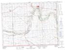
Maps showing Frobisher, 13-3-4-W2, Saskatchewan
Frobisher is a Village located in 13-3-4-W2, Saskatchewan and has an elevation of 577 meters.
- Latitude: 49° 12' 35'' North (decimal: 49.2098082)
- Longitude: 102° 25' 37'' West (decimal: -102.4270000)
- Topography Feature Category: Village
- Geographical Feature: Village
- Canadian Province/Territory: Saskatchewan
- Elevation: 577 meters
- Location: 13-3-4-W2
- Atlas of Canada Locator Map: Frobisher
- GPS Coordinate Locator Map: Frobisher Lat/Long