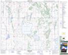
Maps showing Verndale, 12-41-22-W2, Saskatchewan
Verndale is a Unincorporated area located in 12-41-22-W2, Saskatchewan and has an elevation of 545 meters.
- Latitude: 52° 31' North (decimal: 52.5166866)
- Longitude: 105° 3' West (decimal: -105.0505293)
- Topography Feature Category: Unincorporated area
- Geographical Feature: Locality
- Canadian Province/Territory: Saskatchewan
- Elevation: 545 meters
- Location: 12-41-22-W2
- GPS Coordinate Locator Map: Verndale Lat/Long